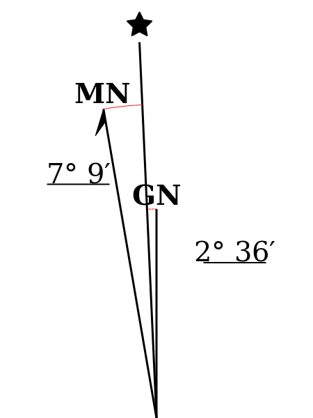
Although many utilities exist for calculating the declination angles, creating a suitable declination diagram manually can be tedious, especially when creating a map series that spans a large area. This is because, as previously mentioned, the declination diagram will be unique to each map, representing the differences between the three norths at the center of the map at a specific point in time. However, the SharedGeo web service creates a declination diagram automatically, returning a scalable image that can be inserted into a map layout using mapping software. This utility uses the NOAA World Magnetic Model (https://ngdc.noaa.gov/geomag/WMM/DoDWMM.shtml).
SharedGeo offers two versions of this free magnetic declination diagram service.
The base URL is: https://mdd.sharedgeo.org/mdd-gen?, but that URL requires several additional arguments to work, including date, lat, lon, and zone where:
date – a decimal date. The whole number is the year and digit after the decimal represent the portion of the year corresponding to a specific month. Minimum required entry is the year (whole number). Decimal month decimal can be calculated using the formula ((month-1) / 12) which creates the results below:
| January = .0 | April = .3 | July = .5 | October = .8 |
| February = .1 | May = .3 | August = .6 | November = .8 |
| March = .2 | June = .4 | September = .7 | December = .9 |
Note: The current magnetic model is valid through 2025.
lat – latitude in decimal degrees of the center of the maplon – Longitude in decimal degrees of the center of the map (positive = East, negative = West)zone – UTM zone of the mapof – Output format – PNG or SVG – PNG is the default, if this argument is not specified.
Example:
https://mdd.sharedgeo.org/mdd-gen?date=2019.0&lat=43.6276212901&lon=-92&zone=15
Two additional arguments are supported to adjust the size
of the output image; width and height. Requesting a larger
image effectively creates higher resolution images and,
therefore, finer line widths and text characters when the
image is reduced in size.
Full documentation of the service can be found here: https://mdd.sharedgeo.org/USNG_Magnetic_Declination_Diagram_Service.pdf
Our past and current projects span:
Creation of unique and affordable approaches to the nation's most difficult geospatial challenges.
Learn more: www.sharedgeo.org